 |
 |
 |
||
Part of the PAGenWeb Project |
||||
Pennsylvania’s Historical Marker Program highlights some of Pennsylvania’s history with more than 2,000 cast aluminum markers. Warren county has its share of interesting history as evidenced by the following collection of eleven highway roadside markers and one city marker:
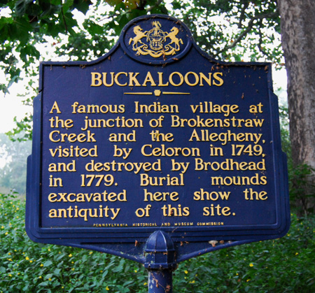
BUCKALOONS
Dedicated: |
October 23, 1947 | |
Marker Type: |
Roadside | |
Category: |
Native American | |
Location: |
Buckaloons Park, near U.S. 62, east of Irvine | |
GPS Coordinates: |
LNG: -76.2574, LAT: 41.83568 | |
Marker text: |
A famous Indian village at the junction of Brokenstraw Creek and the Allegheny, visited by Celoron in 1749 and destroyed by Brodhead in 1779. Burial mounds excavated here indicate the antiquity of this site. |
|
| ® The historical marker is a registered trademark of the Pennsylvania Historical and Museum Commission and the marker text is copyright protected. Used with permission. | ||
 |
||
| Photograph courtesy of the Pennsylvania Historical and Museum Commission | ||
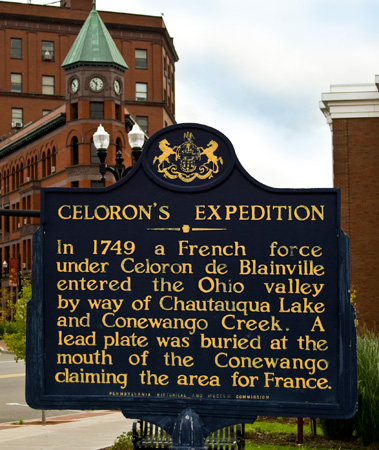
CELORON'S EXPEDITON
Dedicated: |
October 23, 1947 | |
Marker Type: |
Roadside | |
Category: |
Exploration, Government & Politics, Government & Politics 18th Century | |
Location: |
Pennsylvania Ave. (Business U.S. 6) at Hickory Street, in downtown Warren | |
GPS Coordinates: |
LNG: -79.14923, LAT: 41.84482 | |
Marker text: |
In 1749 a French force under Celoron de Blainville entered the Ohio valley by way of Chautauqua Lake and Conewango Creek. A lead plate was buried at the mouth of the Conewango claiming the area for France. |
|
| ® The historical marker is a registered trademark of the Pennsylvania Historical and Museum Commission and the marker text is copyright protected. Used with permission. | ||
 |
||
| Photograph courtesy of Penelope Repko | ||
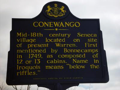
CONEWANGO
Dedicated: |
October 23, 1947 | |
Marker Type: |
Roadside | |
Category: |
Early Settlement, Native American | |
Location: |
Pennsylvania Ave. (Business U.S. 6), Conewango Creek Bridge, Warren | |
GPS Coordinates: |
LNG: -79.14027, LAT: 41.8437 | |
Marker text: |
Mid-18th century Seneca village located on site of present Warren. First mentioned by Bonnecamps, in 1749, as composed of 12 or 13 cabins. Name in Iroquois means "below the riffles." |
|
| ® The historical marker is a registered trademark of the Pennsylvania Historical and Museum Commission and the marker text is copyright protected. Used with permission. | ||
 |
||
| Photograph courtesy of the Pennsylvania Historical and Museum Commission | ||
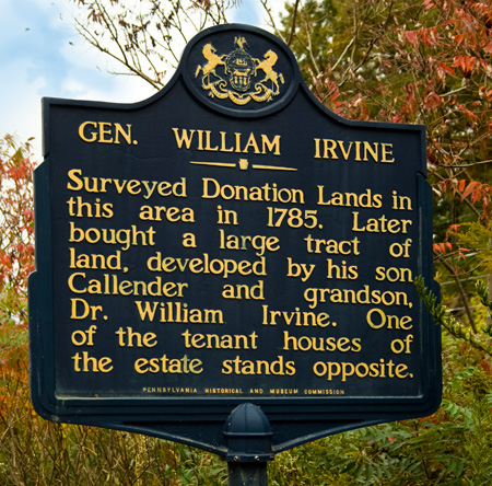
GEN. WILLIAM IRVINE
Dedicated: |
October 23, 1947 | |
Marker Type: |
Roadside | |
Category: |
Professions & Vocations | |
Location: |
Old U.S. 6 (SR 3022) west of U.S. 62, Irvine | |
GPS Coordinates: |
LNG: -79.26173, LAT: 41.83987 | |
Marker text: |
Surveyed Donation Lands in this area in 1785. Later bought a large tract of land, developed by his son Callender and grandson, Dr. William Irvine. One of the tenant houses of the estate stands opposite. |
|
| ® The historical marker is a registered trademark of the Pennsylvania Historical and Museum Commission and the marker text is copyright protected. Used with permission. | ||
 |
||
| Photograph courtesy of Penelope Repko | ||
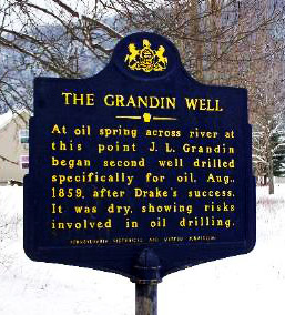
GRANDIN WELL, THE
Dedicated: |
July 15, 1959 | |
Marker Type: |
Roadside | |
Category: |
Business & Industry, Oil | |
Location: |
U.S. 62, 0.4 mile south of the Allegheny River Bridge at Tidioute | |
GPS Coordinates: |
LNG: -79.41688, LAT: 41.67693 | |
Marker text: |
At oil spring across river at this point J.L. Grandin began second well drilled specifically for oil, Aug., 1859, after Drake's success. It was dry, showing risks involved in oil drilling. |
|
| ® The historical marker is a registered trademark of the Pennsylvania Historical and Museum Commission and the marker text is copyright protected. Used with permission. | ||
 |
||
| Photograph courtesy of the Pennsylvania Historical and Museum Commission | ||
HANDSOME LAKE - MARKER IS MISSING
Dedicated: |
October 02, 1946 | |
Marker Type: |
Roadside | |
Category: |
Native American | |
Location: |
PA 59 at Cornplanter | |
Marker text: |
Home of Handsome Lake, the Seneca prophet, was located across the river. It was there that he received supernatural sanction in 1799 to establish the religious cult bearing his name. |
|
| ® The historical marker is a registered trademark of the Pennsylvania Historical and Museum Commission and the marker text is copyright protected. Used with permission. | ||
INDIAN PAINT HILL
Dedicated: |
October 23, 1947 | |
Marker Type: |
Roadside | |
Category: |
Native American | |
Location: |
U.S. 62, 3 miles NE of Tidioute | |
GPS Coordinates: |
LNG: -79.34907, LAT: 41.7084 | |
Marker text: |
Across the river from here deposits of red ochre and adjacent petroleum springs provided the Indians with raw materials for face and body paint. |
|
| ® The historical marker is a registered trademark of the Pennsylvania Historical and Museum Commission and the marker text is copyright protected. Used with permission. | ||
ROBERT HOUGHWOUT JACKSON
|
Dedicated:
|
August 23, 1997 |
|
|
Marker Type:
|
Roadside | |
Category: |
Government & Politics, Government & Politics 20th Century | |
|
Location:
|
Route 426 & Eldred Hill, Spring Creek | |
|
GPS Coordinates:
|
LNG: -79.51777, LAT: 41.86705 | |
Marker text:
|
Lawyer & jurist. Chief U.S. prosecutor, Nuremberg war crimes trials in Germany after World War II. Associate Justice, U.S. Supreme Court, 1941-54; noted for his defense of civil liberties. Served in President Franklin D. Roosevelt's administration starting in 1934; U.S. Solicitor General, 1938-39, & Attorney General, 1940-41. Jackson was born on the family farm here in Spring Creek. |
|
| ® The historical marker is a registered trademark of the Pennsylvania Historical and Museum Commission and the marker text is copyright protected. Used with permission. | ||
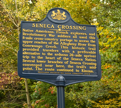
SENECA CROSSING
Date Dedicated: |
November 3, 2007 | |
Marker Type: |
Roadside | |
Category: |
American Revolution, Exploration, Native American, Paths & Trails, Transportation | |
Location: |
Intersection of Warren-Onoville Road (SR1013) & Eqypt Hollow Road, Glade Twp. | |
GPS Coordinates: |
LNG: -79.058948, LAT: 41.888078 | |
Marker text: |
Native Americans, French explorers, and Revolutionary War soldiers all used this 8-mile cross-country portage to access the upper reaches of the Allegheny River from Conewango Creek. This historic trail provided travelers with a preferable alternative to the arduous 26-mile upriver trip to the heart of the Seneca Nation. Several lower branches of Seneca Crossing converged near here, the trail's mid-point. The route continued to Kinzua. |
|
| ® The historical marker is a registered trademark of the Pennsylvania Historical and Museum Commission and the marker text is copyright protected. Used with permission. | ||
 |
||
| Photograph courtesy of Penelope Repko | ||
SUGAR RUN MOUNDS - MARKER IS MISSING
Dedicated: |
October 2, 1946 | |
Marker Type: |
Roadside | |
Category: |
Native American | |
Location: |
PA 59 at Cornplanter | |
Marker text: |
Archaeological excavations immediately to the west of here, revealed three burial mounds, a village site and associated artifacts. The remains represent an outpost of the widespread Hopewellian peoples of the 12th and 13th centuries. |
|
| ® The historical marker is a registered trademark of the Pennsylvania Historical and Museum Commission and the marker text is copyright protected. Used with permission. | ||
THOMPSON'S ISLAND
|
Dedicated:
|
October 23, 1947 | |
|
Marker Type:
|
Roadside | |
Category: |
American Revolution, Military, Native American | |
|
Location:
|
U.S. 62, 9 miles SW of Warren | |
|
GPS Coordinates:
|
LNG: -79.21532, LAT: 41.78407 | |
Marker text:
|
An advance party of Brodhead's expedition of 1779 into the Seneca country had a skirmish here with 30 or 40 Indians, the only fighting which took place in that campaign, and the only Revolutionary battle in northwestern Pennsylvania. |
|
| ® The historical marker is a registered trademark of the Pennsylvania Historical and Museum Commission and the marker text is copyright protected. Used with permission. | ||
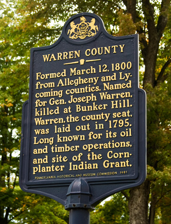
WARREN COUNTY
|
Dedicated:
|
March 12, 1981 |
|
|
Marker Type:
|
City | |
Category: |
Government & Politics, Government & Politics 19th Century | |
|
Location:
|
County Courthouse, 4th Avenue at Market St., Warren | |
|
GPS Coordinates:
|
LNG: -79.147, LAT: 41.848117 | |
Marker text:
|
Formed March 12, 1800 from Allegheny and Lycoming counties. Named for Gen. Joseph Warren, killed at Bunker Hill. Warren, the county seat, was laid out in 1795. Long known for its oil and timber operations, and site of the Cornplanter Indian Grant. |
|
| ® The historical marker is a registered trademark of the Pennsylvania Historical and Museum Commission and the marker text is copyright protected. Used with permission. | ||
 |
||
| Photograph courtesy of Penelope Repko | ||
Return to Warren County history | Miscellaneous page | Warren County genealogy homepage
A proud participant in the USGenWeb and PAGenWeb Projects