CHAPTER XVIII
Norwich Township
TOPOGRAPHY, ETC.—GEOLOGY—COAL MINES— OIL WELLS—POPULATION— OFFICERS FOR 1890— ASSESSMENT, 1837— EARLY SETTLERS—THE OLD NORWICH CHURCH— THE NORWICH CEMETERY ASSOCIATION—STORES IN 1847— MINERAL WELLS— TIMBER LANDS AND SAW-MILLS— NEWERF.
NORWICH TOWNSHIP forms the southeast corner of the county in conjunction with a strip of territory belonging to Liberty township. The divide occupies a central position, reaching an elevation of 2,348 feet above the ocean. From this height the east branch of Potatoe creek flows south and west, to join the main creek running north by the divide; North creek and Portage creek, southeast to the Sinnemahoning portage, and the head-waters of Allegany portage north into the Allegheny river above Port Allegany. The Salt Works branch of the Sinnemahoning also rises in the southeast corner.
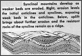
The Emporium and Norwich anticlinal valleys traverse this section, while the Norwich and Clermont synclinals or bituminous coal basins parallel the anticlinals. The highest elevation of the bottom of the Olean conglomerate is found three-fourths of a mile northwest of Keating depot, 2,275 feet above ocean, and the lowest at the Hamlin coal opening, 1,890 feet. The lowest measured point in the township is just below Crosby post-office, where the creek bottom is 1,508 feet above ocean level. The average dip from the Keating summit near the depot to the Lyman Camp mine in the Potatoe creek coal basin is 140 feet per mile, but in sections it ranges from 250 feet per mile to 100 feet. From the Lyman Camp to the Hamlin mine the dip is only eleven feet, and thence to Burnt Hill eighteen feet. From Norwich Hill to Splint mine on the eastern side the dip is 110 feet per mile; the southeastern dip, in the southwestern corner, 132 feet per mile, and the dip between Wolcott-Comes creek summit and well No. 1, twenty-two feet per mile. There are many local dips in the coal beds of this township, while the rock outcrop extends vertically downward to the upper Chemung shale and sandstone, a distance of 1,240 feet (as at Coal Pit mines, which open 2,183 feet above tide), from the shale overlying the Dagus coal bed. This stratum shows 290 feet of coal measures, including Olean conglomerate, 450 feet of Mauch Chunk and Pocono, 300 feet of red Catskill and from 150 to 250 feet of Chemung. The 290 feet of coal measures show fifteen feet of shale, three of gray slate, five of Dagus coal, one and one-half of fire-clay, thirty-three of shale and slate, one and one-half of Clermont coal, one and one-half of fire-clay, fifty of Johnson run sandstone, five of black slate, two and one-half of Alton upper coal, eight of fire-clay and shale, three-fourths of Alton middle coal, four and one-fourth of shale and sandstone, four of Alton lower coal, two of fire-clay, forty-eight of Kinzua creek sandstone, two and one-third of Marshburg upper coal, two and two-thirds of fire-clay and fifty-five of Olean conglomerate and sandstone. The section was made from the survey by F.E. Gleason in 1876. The conformation at the Rock coal mine, 2,138 feet above tide, varies a little, showing a fifteen-feet exposure of flaggy sandstone at the opening, while the Hamlin and Splint coal beds rest on Kinzua creek sandstone. The Blue coal opening is 2,028 feet above tide; the Spring, 2,035 feet, and Rochester cannel mines, 2,074 feet. In the test of these coals is was found that Coal Pit coal yielded about 56.2 of fixed carbon and 63.6 of coke; Spring, 59.3 and 67.3, respectively; Hamlin, 61.6 and 69.2; Blue, 62.1 and 69; Rock, 58 and 70; Lyman Camp, 57.5 and 68.8; Charley, 49.2 and 64.2; Block coal, 38.8 and 61.5; Burnt Hill (cannel), 48.1 and 66.3, and Rochester (cannel) 37.7 and 75.9 per cent of fixed carbon and coke. In the gas test, one pound from the Hamlin seam yielded 5.10 cubical feet; from the Spring and Blue seams, over four; from the Block, over three and one-half, and from the Burnt Hill cannel almost three cubical feet. In 1875-76 explorations on the Backus and Chadwick lands (known as the Butterfield purchase), in the southeast and southwest corners of Sergeant and Norwich townships, were reported by Seth Backus, of Smethport. Well No. 1 opened 2,232 feet above ocean level in five and one-fourth feet of soil, resting on a bed of shale from fourteen to twenty feet in depth. This well reached a depth of about 1,400 feet, striking white, fine, micaceous sand rock at the bottom, passing through thin beds of coal (thirty feet below the mouth) and iron ore. In well No. 2 a heavier coal deposit was found sixty-four feet below the surface, and in well No. 4 about forty-seven feet below the top. In the vicinity of No. 4 the Buffalo Coal company opened a well 2,173 feet above ocean level, and a depth of almost 127 feet bored through the Marshburg coal. Up Indian run several four-inch beds have been opened.
Near Hamlin, an oil well was drilled in 1875-76 to a depth of 2,002 feet, and in June, 1877, the great flagstone quarry was opened by Orlando Gallup, and worked by John Digel.
The population of Norwich township in 1880 was 431. In 1888 there were 96 Republican, 63 Democratic and 3 Prohibitionist votes cast, or a total of 162, representing a population of 810.
The officers for 1890 are as follows:
- Supervisors
- B.D. Colegrove
- E.E. Burdick
- School Directors
- J.B. Oviatt
- N.C. Gallup
- Justice Of The Peace
- M. Blodgett
- Constable
- Ellis Griffith
- Town Clerk
- J.B. Oviatt
- Auditors
- W.E. Wilson
- C.A. Anderson
- C.D. Comes for one year
- Collector
- O.D. Gallup
- Judge Of Election
- R.N. Wilson
- Inspectors
- W.O. Gallup
- W.B. Richey
The assessment of residents of Norwich township in 1837 shows the names of John Abbey, Tim Abbey, John Avery, Dave Allard, Joe Apple, I. Burlingame, William Brewer, Wheeler and Henry Brown, George and Daniel A. Easterbrooks, Rowland Burdick, Nathan Brewer, Asa Cotton, Dave Comes, Elias J. Cook, Benjamin and Jonathan Colegrove, Francis J. Chadwick, Edward Corwin and son, Amos Coats, Henry Chapin, Edward Dickenson, Levi Davis, Jr., R. Eastwood, John Ellis, Job Gifford, John S. Gunning, O.W. Wheeler, Jabez, N.C. and A.E. Gallup, Luke B. Gibson, J.W. Howe, John Housler, Ben Haxton, L. and Hiram Havens, Horatio and William Hall (Wm. owned grist-mill), Thomas Hookey, George and H. Jacox, Henry Lasher, Asenath Lawrence, Levi Lathrop, Samuel Messenger, Abner Miller, __________ Marsh, I. Murphy, Eben Pattison, Daniel Rifle, Nathan Robbins, Esseck Smith, William Smith, Henry Scott, Levi Thomas, Asa Townes, Rhoda White, Samuel Wiswall (trader), William White, Tim and L.F. Wolcott. Henry Scott was assessor, and he recommended Daniel Rifle and Esseck Smith for collectors.
The first permanent settlement was made in 1815 by Jonathan Colegrove, the Abbeys and Wolcotts from Norwich, Chenango Co., N.Y., with others from various towns, giving the township the name of their old home. William Smith and the Whites and Corwins also settled in Norwich…William Gifford, who was born in Norwich township in 1821, died June 26, 1889, at Smethport…Edward Corwin, who served in the Revolution for six years and a quarter, came with his family to Norwich in 1822, and in 1828 settled at Smethport. Ghordis Corwin, the son, died in 1876, leaving $800 to the Baptist church, which he joined here in 1836.
The old Delmar Church, the first organized in the western part of Tioga county, lost seventeen members in 1820-21, when the old Norwich church of McKean county was founded. In 1876 James Steele, of Port Allegany, was said to be the last survivor of the first members.
The Norwich Cemetery Association was incorporated in November, 1874, with W.J. Colegrove, A.P. Brewer, O.D. Gallup, D.D. Comes and Orlando Gallup, trustees.
Colegrove is a thriving village, located on the Western New York & Pennsylvania Railroad. The post-office there was presided over, up to 1880, by W.J. Colegrove, to whose efforts the establishment of an office at this point was due. Jonathan Colegrove is the present postmaster. In 1883 the general mercantile business of W.J. Colegrove & Son was purchased by C.A. Anderson. The Heinemann lumber industry and other lumber interests in the vicinity contribute principally to the trade of the village. A pumping station of the National Transit Company is located here.
In May, 1847, the stores of C.R. & B.O. Burdick and J.F. Gallup were opened in Norwich. Gardeau is the new postal name given to the old Elk-lick.
The Parker Magnetic Mineral well, near the corner of McKean, Potter and Cameron counties, nine miles from Emporium, was analyzed in July, 1888, and found to contain 627.59 grains of mineral matter - Silica, 1.33; Mag. Chl., 109.84; Cal. Carb., 11.95; Cal. Chl., 221.92; Sod. Chl., 282.55; Pot. Chl., traces. In 1887 a mineral spring was discovered at Four Mile on N.P. Minard's lands. The present site of the flowing well has always been known, since the earliest history of the country, as the Great Elk-lick. Although it is not certain that the water flowed from the ground in its present strength, it undoubtedly possessed saline qualities which attracted deer and elk in great numbers. In 1865 N. H. Parker drilled a well 640 feet deep in the bed of the old spring, and struck the present vein of mineral water that flows from the top of the well. Mr. Parker drilled the well in the hope of finding oil. The water was allowed to flow uncared for and unthought of, until about four years ago, when George Broucham, who was working for Mr. Parker in the saw-mill, was laid up with an attack of calculus, which had been troubling him for several years. Having a fondness for this water, he commenced in drinking it from the well, and began to recover immediately. The flow of the spring, which never varies perceptibly, is about sixty-five gallons per hour. The spring was purchased by the Parker Mineral Spring Company in 1888. They have built a good hotel and commodious bath-house, which are under efficient management. In February, 1890, H.C. Crawford bought 1,400 acres of timber land, on the line of the Western New York & Pennsylvania Railroad, about fifteen miles south of Port Allegany, and engaged in cutting timber on it. He has built two saw-mills, one at Gardeau, and the other at Sizerville.
Digel is the name of a post-office in this township.
Newerf, formerly known as Spearsburg and later as Crosby, is six miles south by east of Smethport. Here at the old Spearsburg mill, lately owned by G.C. Carpenter & Son, people in this vicinity and Smethport, no later than 1873, came to have lumber planed. This mill was burned about 1884. Here also were the oil extract works written of in the chapter on the oil fields.
The town is pleasantly located on the line of the Western New York & Pennsylvania Railroad, and contains several frame houses, a billiard room, a tonsorial parlor, a building recently erected for a foundry, not yet in operation, a boarding house, which under the management of Ed. Elbridge, two blacksmith shops, and two saw mills, one owned by the Crosby lumber company and the other by James White. There is also a school-house which was built in the fall of 1882. The school is managed by Mrs. Cary of Bradford. Besides all these many improvements there are two stores, one owned by the Crosby Lumber Company, and the other by M. Erhart. The last store contains the post-office and M. Erhart is the postmaster. At the rate of the present output of hemlock lumber, it will be but a few years when people around here will be compelled to resort to other industries, in order to gain a livelihood. The forests are being stripped of the hemlock very rapidly and no doubt the present generation will live to see hemlock as scarce as pine is. After the little hills are stripped of the hemlock the land will be of little use save for grazing, and then the sheep will have to be shod, for the hills are so steep and stony that they can not hold their footing.