Fayette County Genealogy Project
Alan Rockwell's Fayette Gazetteer
| GENEALOGY OF THE MUNICIPALITIES OF FAYETTE COUNTY |
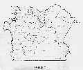
Fayette County
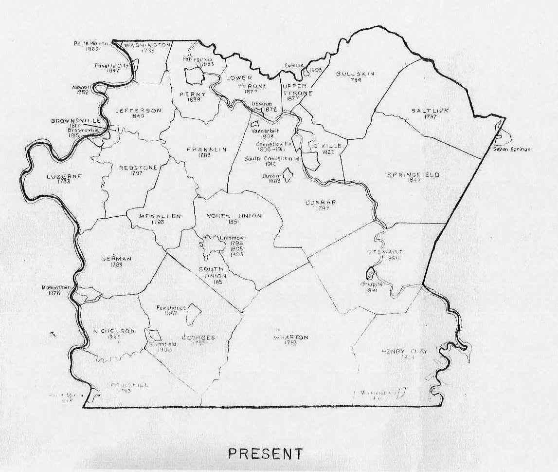
Present Day |
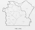
Fayette County
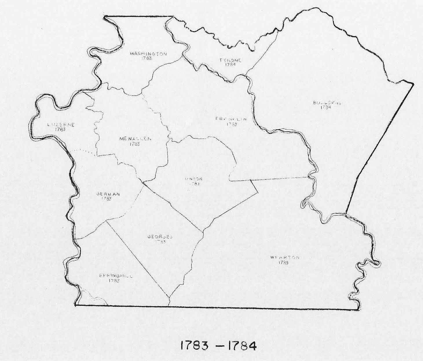
1783 - 1784 |
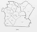
Fayette County
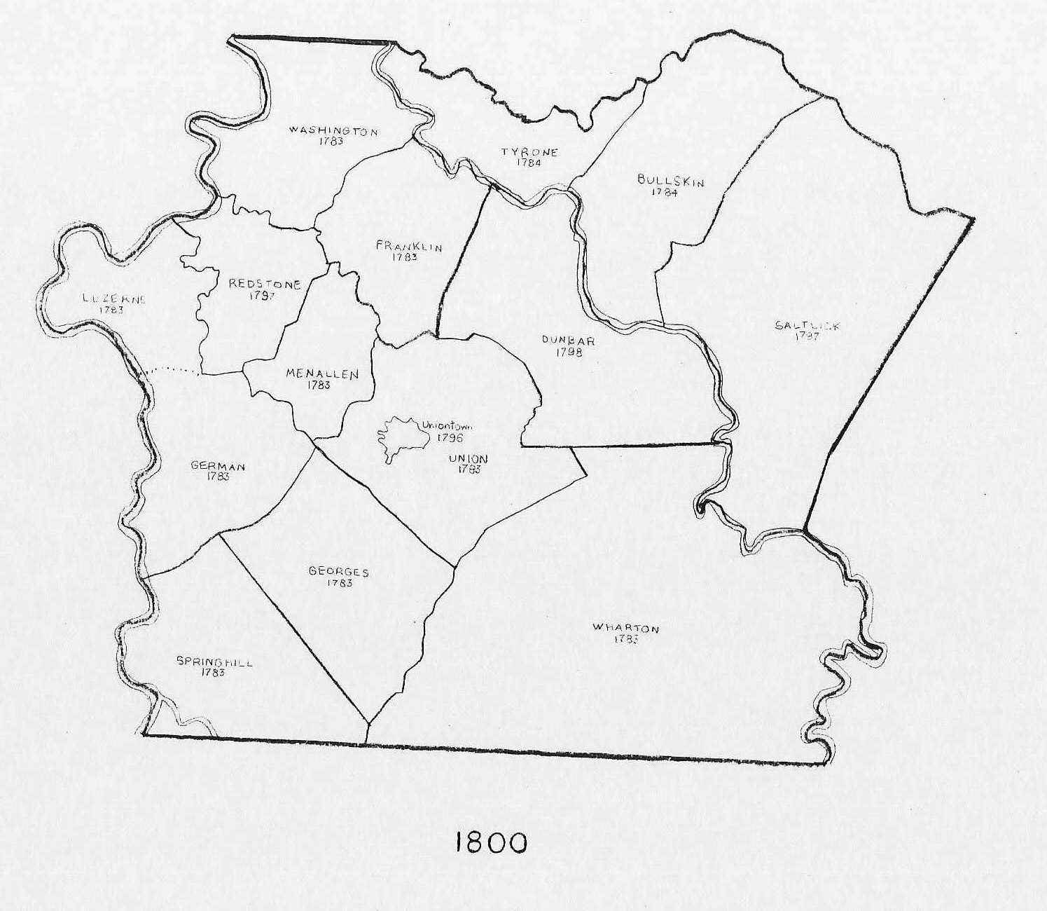
1800 |
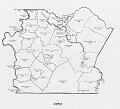
Fayette County
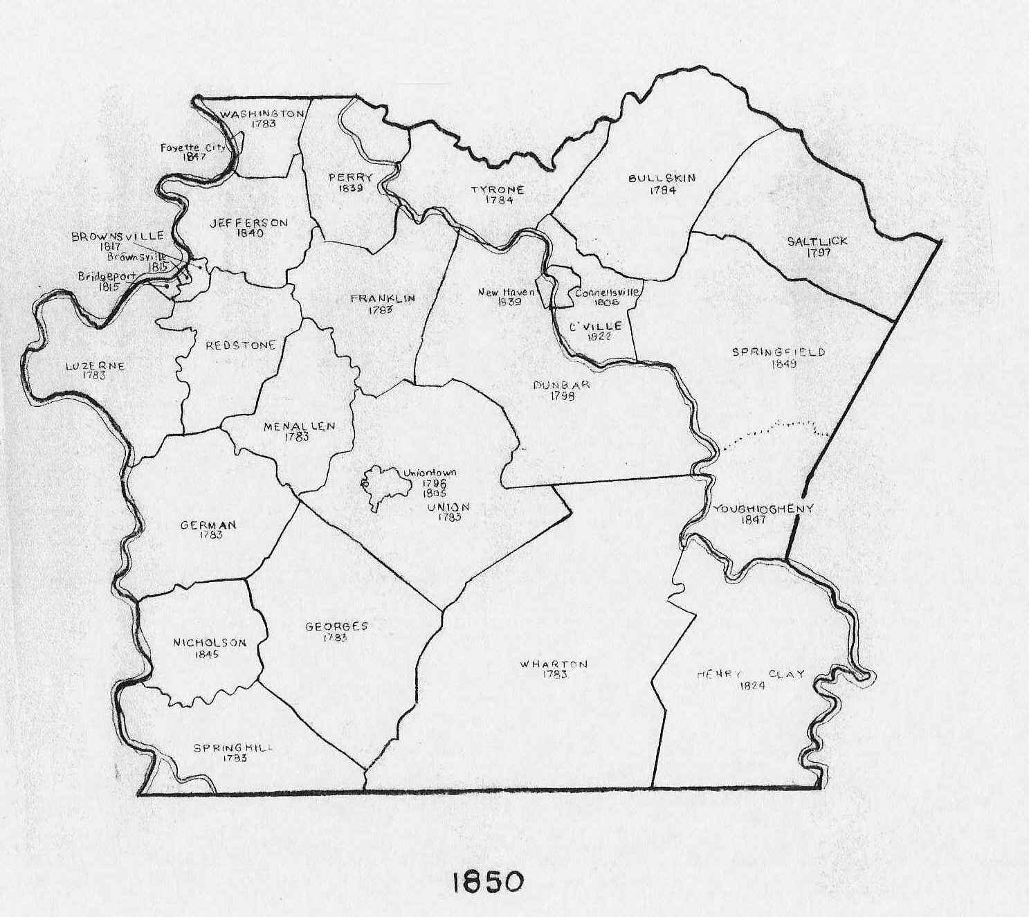
1850 |

Fayette County
1900 |
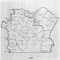
Fayette County
1950 |
Click on the small image to view a larger image
A combined print of the six maps shown above was purchased from:
Fayette County Tax Assessment Office
61 East Main Street, Uniontown, PA 15401-3514
TOWNSHIPS
That portion of Fayette County which lies southwest of
the Youghiogheny River was formed and erected out of Westmoreland County by an act of the General
Assembly on 26 September 1783. It was subdivided into the nine townships on 23 December 1783 during
the first term of the Court of Quarter Sessions and Common Pleas held for Fayette County.
That portion of Fayette County which lies northeast of the Youghiogheny River was annexed to it
from Westmoreland County by an act of the General Assembly on 17 February 1784. This addition was
divided into two townships in March 1784.
- Bridgeport Township was created in November 1815 from the northeastern
corner of Luzerne Township which had been incorporated as the borough
of Bridgeport on 9 March 1814.
- Brownsville Township was created in November 1817 from the northwestern
corner of Redstone Township which included the borough of Brownsville
and a small territory beyond the eastern limits of the borough.
- Bullskin Township was created in March 1784 from that portion of Donegal
Township which the General Assembly had transferred from Westmoreland
County. That portion of Bullskin Township east of the top of Chestnut
Ridge was used to create Saltlick Township in December 1797. The southern
portion of Bullskin Township was used to create Connellsville Township on
31 October 1822.
- Connellsville Township was created on 31 October 1822 from the southern
portion of Bullskin Township.
- Dunbar Township was created in December 1798 from the eastern portion of
Franklin Township.
- Franklin Township, an original township, was created in December 1783. A
northern corner of its territory was used to create Perry Township on 7
June 1839. The eastern portion of its territory was used to create Dunbar
Township in December 1798.
- Georges Township, an original township, was created in December 1783. The
western corner of its territory was used to create Nicholson Township on
19 December 1845.
- German Township, an original township, was created in December 1783. The
southern corner of its territory was used to create Nicholson Township on
19 December 1845.
- Henry Clay Township was created on 9 June 1824 from the eastern portion of
Wharton Township. The northwestern corner of its territory was used to
create Stewart Township on 17 November 1855.
- Jefferson Township was created in June 1840 from the southern portion of
Washington Township.
- Lower Tyrone Township was created on 5 September 1877 from the western
portion of Tyrone Township.
- Luzerne Township, an original township, was created in December 1783. The
northeastern corner of its territory was used to create the borough of
Bridgeport on 9 March 1814 and Bridgeport Township in November 1815.
- Menallen Township was created by Westmoreland County on 6 April 1773 as
one of its original townships. Fayette County made it one of its original
townships in December 1783. its territory was divided in December 1797 with
the eastern or upper portion retaining the name Menallen Township and the
western or lower portion being named Redstone Township.
- Nicholson Township was created on 19 December 1845 from portions of
Georges, German, and Springhill Townships.
- North Union Township was created on 11 March 1851 from that portion of
Union Township which was north of the National Road (US Route 40).
- Perry Township was created on 7 June 1839 from portions of Franklin,
Tyrone, and Washington Townships.
- Redstone Township was created in December 1797 from the western or lower
portion of Menallen Township. The northwestern corner of its territory was
used to create Brownsville Township in November 1817.
- Salt Lick
Township was created in December 1797 from that portion of Bullskin
Township east of the top of Chestnut Ridge. The southern portion of its
territory was use to create Youghiogheny Township on 11 December 1847. The
southern portion of its territory was use to create Springfield Township on
10 March 1849.
- South Union Township was created on 11 March 1851 from that portion of
Union Township which was south of the National Road (US Route 40).
- Springfield Township was created on 10 March 1849 from the southern portion
of Saltlick Township. It absorbed the northern remainder of Youghiogheny
Township on 17 November 1855 when Stewart Township was formed.
- Springhill
Township was created by Cumberland County, and its original territory
included what is now the southern portion of Fayette County, all of Greene
County, and the southern portion of Washington County. It became part of
Bedford County when it was created in 1771, and Westmoreland County made it
one of its original townships on 6 April 1773. The eastern portion of its
territory from the top of Laurel Hill east to the Youghiogheny River was used
to create Wharton Township in July 1783. Fayette County made it one of its
original townships in December 1783. The northern corner of its territory was
used to create Nicholson Township on 19 December 1845.
- Stewart Township was created on 17 November 1855 from portions of Henry
Clay, Wharton, and Youghiogheny Townships.
- Tyrone Township was created by Bedford County. Westmoreland County made it
one of its original townships on 6 April 1773, and Fayette County made it a
township in March 1784 after the General Assembly had transferred it from
Westmoreland County. The western portion of its territory was used to
create Perry Township on 7 June 1839, and it was eliminated on 5 September
1877 when its remaining territory was divided into Upper and Lower Tyrone
Townships.
- Union Township, an original township, was created in December 1783, and
was eliminated on 11 March 1851 when its territory was divided into North
and South Union Townships.
- Upper Tyrone Township was created on 5 September 1877 from the eastern
portion of Tyrone Township.
- Washington Township, an original township, was created in December 1783.
The eastern corner of its territory was used to create Perry Township on 7
June 1839. The southern portion of its territory was used to create
Jefferson Township in June 1840.
- Wharton Township was created by Westmoreland County in July 1783 from a
portion of Springhill Township. Fayette County made it one of its original
townships in December 1783. its territory extended from the top of Laurel
Hill east to the Youghiogheny River. The northern portion of its territory
was transferred to Franklin Township in 1793. its territory was divided on
9 June 1824 with the western portion retaining the name Wharton Township and
the eastern portion being named Henry Clay Township. The northeastern corner
of its territory was used to create Stewart Township on 17 November 1855.
- Youghiogheny Township was created on 11 December 1847 from the southern
portion of Saltlick Township, and was eliminated on 17 November 1855 when
a portion of its territory was used to create Stewart Township and its
remaining territory was annexed to Springfield Township.
- Young Township is a misnomer that was used to refer to Saltlick Township
both locally and in some official transactions during its early years.
CITIES, BOROUGHS,
and OTHER NON-INCORPORTED COMMUNITIES
- Adelaide is located in Dunbar Township.
- Alicia
- Allison
- Arnold City
- Banning
- Belle Vernon was laid out by Noah Speer in 1813, and incorporated into a
borough by an act of the General Assembly on 15 April 1863. Part of Belle
Vernon is located in Westmoreland County.
- Bitner
- Braznell
- Bridgeport was laid out by Rees Cadwallader in 1794, and incorporated into
a borough by an act of the General Assembly on 9 March 1814.
- Broadford
- Brownsville was incorporated into a borough by an act of the General
Assembly on 9 January 1815.
- Bute is an alternate name for Leisenring No. 2.
- Cardale
- Chalk Hill is located in Wharton Township.
- Collier is located in Georges Township.
- Connellsville was laid out by Zachariah Connell in 1793 and was
incorporated into a borough by an act of the General Assembly on 1 March
1806. It was incorporated as a city in 1911.
- Continental No. 1
- Continental No. 2
- Continental No. 3
- Dawson was incorporated into a borough on 8 June 1872.
- Dearth is located in Menallen Township.
- Dunbar was incorporated into a borough in 1883. It is located in Dunbar
Township.
- East Fredericktown
- East Millsboro is located in Luzerne Township.
- Edenborn
- Everson was incorporated into a borough in 1903.
- Fairbank
- Fairchance was incorporated into a borough in 1887.
- Farmington is located in Wharton Township.
- Fayette City was incorporated into a borough in 1947.
- Filbert
- Flat Rock is located in Henry Clay Township.
- Footedale
- Gates
- Grindstone
- Heisterburg is located in Luzerne Township.
- Hopwood
- Isabella is located in Luzerne Township.
- Isabelle
- Jimtown
- Juniata
- Keisterville is located in Menallen Township.
- Kyle
- Lake Lynn
- Lambert
- Leckrone
- Leisenring is an alternate name for Leisenring No. 1.
- Leisenring No. 1 is located in Dunbar Township, and is also known as
Leisenring.
- Leisenring No. 2 is located in Dunbar and North Union Townships, and it is
also known as Bute or West Leisenring.
- Leisenring No. 3 is located in Dunbar Township, and it is also known as
Monarch.
- Leith is located in South Union Township.
- Lemont or Lemont Furnace is located in North Union Township.
- Little Summit
- Marguerite
- Markleysburg is located in Henry Clay Township. It was incorporated into a
borough in 1893.
- Martin
- Masontown was incorporated into a borough in 1876. It is located in German
Township.
- Maxwell is located in Luzerne Township.
- McClellandtown
- McClure
- Monarch is an alternate name for Leisenring No. 3.
- Monroe
- Mount Braddock is located in North Union Township.
- Mount Independence is located in North Union Township.
- New Haven was incorporated into a borough in 1839 from community in Dunbar
Township on the west side of the Youghiogheny River. It became part of the
City of Connellsville in ____.
- New Salem
- Newell was incorporated into a borough in 1952.
- Normalville
- Ohiopyle was incorporated into a borough in 1891 from a community in
Stewart Township originally known as Falls City.
- Oliphant or Oliphant Furnace is located in Georges Township.
- Oliver is located in North Union Township
- Oliver No. 1 is an alternate name for a portion of Oliver.
- Oliver No. 2 is an alternate name for a portion of Oliver.
- Oliver No. 3 is an alternate name for Thaw.
- Orient
- Palmer
- Perryopolis was incorporated into a borough in 1953.
- Phillips is located in North Union Township.
- Plumsock is an older name for an area now known as Upper Middletown.
- Point Marion was incorporated into a borough in 1893.
- Ralph is located in German Township.
- Republic
- Revere is located in South Union Township.
- Ronco
- Rowes Run
- Royal
- Seven Springs was incorporated into a borough in ____.
- Shamrock
- Shoaf
- Smithfield was incorporated into a borough in 1900.
- Smock is located in Franklin or Menallen Township.
- South Connellsville was incorporated into a borough in 1910.
- Star Junction
- Summit Mines
- Taylor
- Thaw is located in North Union Township, and it is also known as Oliver
No. 3.
- Trotter is located in Dunbar Township.
- Uledi is in Menallen Township.
- Uniontown was incorporated into a borough on 4 April 1796. 1805. 1903. It
is now a city.
- Upper Middletown is located in Franklin Township.
- Vances Mill is located in North Union Township.
- Vanderbilt was incorporated into a borough in 1903.
- West Leisenring is an alternate name for Leisenring No. 2.
- Whitsett
- Wick Haven
- Woodstock is an older name for Hopwood.
- Wynn is located in Georges Township.
- York Run is located in Georges Township.
- Youngstown is located in North Union Township.
This page was created in November 1998, and last updated on 30 January 2003.
©1998-9 by Alan R. Rockwell, Jr.
Return to Research Aids Index
Return to Main Index
|